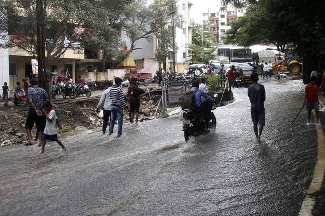
Though the southwest monsoon this year is at its fag end, there are no immediate signs of rain over Pune ending anytime soon. Since the beginning of this week, Pune has experienced intense spells of rain around midnight, which sometime go on till the next morning. The rainfall intensity during these incidents ranged between 45mm and 90mm in a 24-hour period. Most of the rainfall occurred within a window of two to four hours, except on Wednesday, when it rained from 8 pm on Wednesday till 6 am on Thursday
A close look at the 24-hour rainfall record maintained by the India Meteorological Department suggests that the wettest spell of the last three days was not recorded on Thursday morning, which received 53.1mm rain. Rainfall during the same period in the city, recorded on Wednesday and Tuesday, was 87.3mm and 55.9mm, respectively.
What caused such intense rain in the last three days?
The monsoon is presently in its very weak phase as it is fast approaching withdrawal. Despite this, the two persisting weather systems – an upper air cyclonic circulation lying over Konkan-Goa-Karnataka and a system over Rayalaseema, Telangana and parts of Maharashtra, contributed to some rain activity over the state during this week. On Thursday, a trough developed that ran between south-central Arabian Sea, through Maharashtra, Chhattisgarh and all the way up to Bihar.
Why did it rain in the evening or night?
This was mainly because of the convective activity associated with soaring day temperature, along with moisture levels over Pune city. For instance, the moisture level recorded on Tuesday was 91 per cent, which is a normal moisture level recorded over a coastal city at any time of the year. The day temperatures fluctuated between 28 degrees Celsius and 32 degrees Celsius during peak afternoon hours, and largely remained a notch above normal.
As a result of these temperature fluctuations, IMD officials said a phenomenon called solar insolation occurred. Simply put, when the prevailing cloud cover during the day gives some way for solar radiation to cut through and reach the earth’s atmosphere, this results in a sudden spike in day temperatures. This, in turn, pushes up the moisture levels and leads to formation of Cumulous Clouds (Cu) and later Cumulonimbus clouds(Cb). Cb clouds are known to cause convective activities — thunder, lightning and intense rainfall within a short span of time, explained Anupam Kashyapi, head of the weather department of IMD, Pune.
What is the forecast for the next few days?
According to IMD, the thunderstorm will continue even on Friday as the prevailing cloud cover remains hovering over the city. Though the rainfall intensity is expected to reduce after Friday, light rain accompanied by thunder will continue, said meteorologists.
Recent Queries
-

what is section of IPC 234??
7 year(s) ago- priya

